


90s streak ends soon, near daily rain chances into next week
The September sizzle persisted today, and with more sunshine, it got a little hotter. Temperatures climbed into the low to mid-90s. Springfield even managed to tie the record high for the date at 95°. The 90° streak should persist into at least Wednesday, marking the longest run of 90° days in Springfield since 1983. Record [...]
The September sizzle persisted today, and with more sunshine, it got a little hotter. Temperatures climbed into the low to mid-90s. Springfield even managed to tie the record high for the date at 95°.

The 90° streak should persist into at least Wednesday, marking the longest run of 90° days in Springfield since 1983.


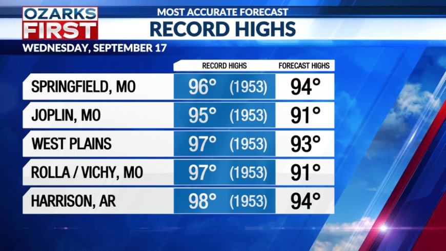
Record highs should be out of reach, but not by much.


As for rain, like Tuesday, it looks like drier air east of Hwy. 65 will keep most areas there dry. Spotty afternoon and evening showers and storms will fire up again, mainly west of Hwy. 65.

The pattern finally shifts gears on Thursday as a storm system moves through the Upper Midwest. A weak cool front will make it through the area Friday, finally knocking temperatures back to levels more typical for mid-September.
Rain chances will run higher across the Ozarks Thursday into Friday, but they will remain scattered. This means some locations won't see rain. The risk for rain should shift east on Friday afternoon.

Weekend weather definitely looks cooler than this past weekend. Look for partly cloudy skies with comfortable temperatures. Rain is possible both days, but should be scattered in nature.
Another cool front will approach early next week, generating scattered showers and thunderstorms on Monday. Drier weather will move in behind the front. We're probably not done with hot September weather, with another burst of heat showing up later next week.
What's Your Reaction?


