


Friday, May 2 forecast: One more hit of widespread rain today


We have one more widespread rain event to overcome today before we start to move out of this excessively wet pattern this weekend. Rain will likely return in the middle of next week, possibly as early as Tuesday evening.


Rain and thunderstorms have broken out across Oklahoma this morning. This rain is coming to areas near and south of I-44 this morning through the midday hour. Widespread rain should begin to move out of the Ozarks this afternoon, but additional scattered showers are possible with a cold front later today into this evening.


An additional 0.25" to 0.50" of rainfall is possible today. A cut-off storm system will linger to our east, but we'll stay dry overnight.


A few showers are possible east of Highway 65 on Saturday where this cut-off rain system will linger. Most spots will stay dry on Saturday, and Sunday is looking really nice. Temperatures this weekend will run in the mid-60s for highs and the low 40s for lows.


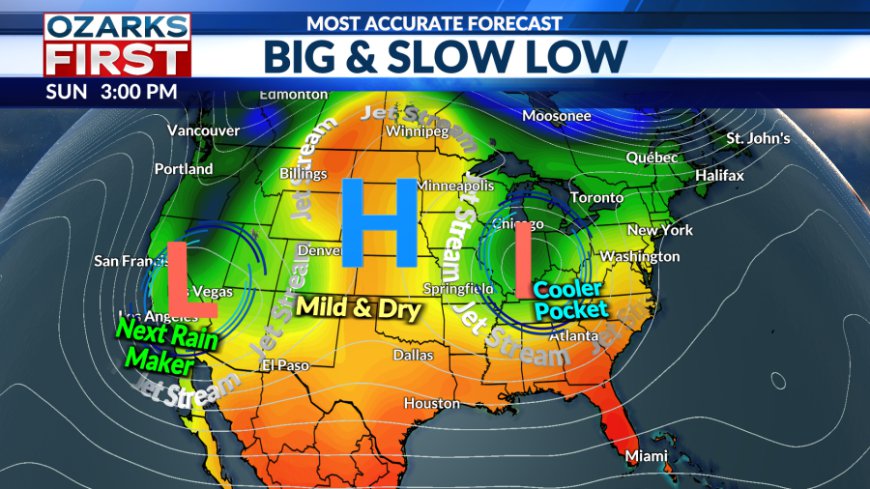
That cut-off will slowly pull off to the east early next week, with another cut-off storm in the Southwest. It's a blocky pattern that usually causes the progression of storms to slow down. For a short time will find ourselves in the sweet spot between storms where the weather will be quiet. This will last for a few days from late in the weekend into Tuesday of next week.

After that, we'll find the western cut-off forcing its way into the middle of the country. Rain chances will return by late Tuesday and may stick around into the following weekend thanks to the slow movement of the storm. This will lead to a showery, cool period of weather. At this time, no severe weather is expected, and the rain doesn't look heavy enough to warrant flooding concerns.

What's Your Reaction?
 Like
0
Like
0
 Dislike
0
Dislike
0
 Love
0
Love
0
 Funny
0
Funny
0
 Angry
0
Angry
0
 Sad
0
Sad
0
 Wow
0
Wow
0


