National Weather Service simplifies winter advisories
With winter weather approaching, you can expect to see fewer types of winter weather advisories this year. The National Weather Service is consolidating how they will warn about cold weather and winter storms. The new approach focuses on a "cold is cold" approach. The NWS Cold Product Suite will allow NWS to communicate that cold [...]

With winter weather approaching, you can expect to see fewer types of winter weather advisories this year. The National Weather Service is consolidating how they will warn about cold weather and winter storms.
The new approach focuses on a "cold is cold" approach. The NWS Cold Product Suite will allow NWS to communicate that cold is dangerous with or without wind. Wind chill factors will still be used, although not emphasized as much for public safety.
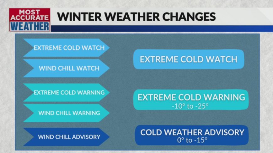
An Extreme Cold Watch and a Wind Chill Watch will become an Extreme Cold Watch. An Extreme Cold Warning and Wind Chill Warning will be consolidated to an Extreme Cold Warning. A Wind Chill Advisory now becomes a Cold Weather Advisory.
The National Weather Service is consolidating Hard Freeze Watch and Freeze Watch to a Freeze Watch. A Hard Freeze Warning and a Freeze Warning will become a Freeze Warning.
For the Ozarks, a Cold Weather Advisory will be between 0° to -15°. An Extreme Cold Warning will qualify at -10° to -25°.
In 2023, the National Weather Service lowered the criteria for Winter Storm Warnings. For most of Missouri, and all of the Ozarks, a prediction of 5″ of snow will be eligible for a warning. In the past, the criteria started at 6″ of snow.
For Arkansas, the threshold will be 4″ of snow. The amount for ice and sleet has not changed. You can see an interactive map here.
What's Your Reaction?


