


Summer ridge still wrestling with a nearby front
Central Missouri is experiencing rain and clouds, while the south is still hot and humid with an Extreme Heat Warning in effect, and a shift in the pattern is expected to bring more rain and cooler temperatures in early August.
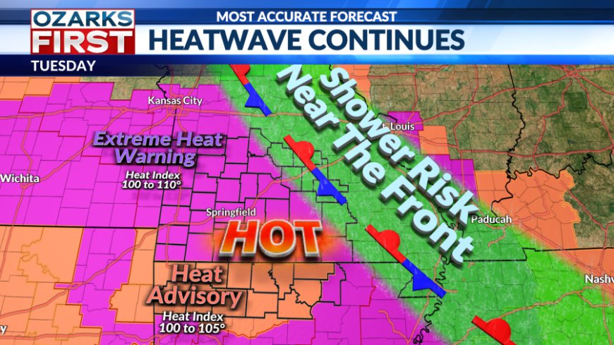
Monday came with some rain and clouds closer to Central Missouri. Meanwhile, to the south, heat and humidity continue to rule. An Extreme Heat Warning remains in effect through at least Thursday of this week.

A boundary draped across areas south of I-70 will continue to serve as a focus for potential showers and thunderstorms tonight, with quiet weather to the south.


The front will get shoved a bit further north Tuesday, but will remain close enough to trigger some spotty showers and thunderstorms over the Eastern Ozarks. Further west, another hot and dry day can be expected.

The front should finally get nudged out of the area by Wednesday, with day shaping up to be a bright and hot one.
Temperatures each day this week will slowly climb, maybe a degree or so each day through Thursday.

There may be an opportunity for more clouds and even a little rain starting Friday and continuing through the upcoming weekend. An area of unsettled weather will move around the summer ridge before shifting east through Missouri and into Illinois through Sunday. This should weaken the ridge somewhat, and it may also push a weak boundary into the area.


At this stage, this looks like only a small speed bump in what will overall be a hot and mostly dry pattern through the end of the month. The longer-range pattern looks more promising for rain and cooler highs. The summer ridge looks like it will shift into the West, creating more of an opportunity for fronts to drop into the Ozarks. This shift in the pattern should occur during the early days of August, and it could result in better rain chances and an easing of the heat.
What's Your Reaction?


