Tuesday, December 3 forecast: Weather whiplash as temperatures swing from frigid to fine
This morning was very cold with many spots getting down to the teens! Winona, MO was the coldest this morning with a temperature of just 12°... BRRR! These were the coldest readings for many since this past January, just another sign that we're heading into winter. The frigid start to the day gave way to [...]

This morning was very cold with many spots getting down to the teens! Winona, MO was the coldest this morning with a temperature of just 12°... BRRR! These were the coldest readings for many since this past January, just another sign that we're heading into winter.

The frigid start to the day gave way to highs in the low 40s during the afternoon. A quick round of low clouds marked the arrival of some warmer air trying to move back in.

It won't be as cold tonight as winds pick up out of the southwest. This will keep the air stirred up, preventing most locations from going below freezing. Despite the warmer temperatures, the increased winds will continue to drive wind chills down below freezing.

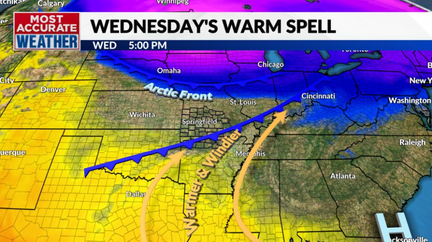
The winds will continue to increase into Wednesday, becoming gusty by late morning. The westerly winds will push warmer air back into the Ozarks leading to a quick pop in temperatures. Everyone will warm well into the 50s with locations to the south likely topping 60°.

The first of a pair of fronts will move through during the afternoon with the arctic front arriving Wednesday night. The arctic blast will drive down wind chills into the single digits early Thursday with high temperatures that will remain below freezing in some areas.


The week will end with a frigid feel in the morning but will come with the promise of warmer weather over the weekend as winds again pick up out of the south.


Southwest winds and sunshine will push temperatures well into the 50s Saturday. The warming trend may get blunted by incoming clouds Sunday and an increasing risk of showers. Despite the headwinds to warmer weather, we'll still enjoy highs in the 50s with the possibility of 60° if the clouds are slower to arrive.

Monday is shaping up to be a transition day and may come with some clouds along with cool temperatures before the next arrival of winter air Tuesday.
What's Your Reaction?


