


Wednesday, July 16 forecast: Storm chances dive after Thursday as heat and haze takes over
Scattered storms and showers are possible today and Thursday, with a significant pattern shift bringing hot and dry conditions for the weekend and into next week.
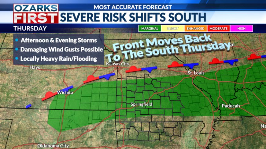
Rain chances remain alive as we move into the back of the week. In fact, Thursday is looking ripe for scattered storms across much of the area. These will be our final shots at rain ahead of an extended stretch of hot & dry conditions.
A risk for spotty showers this evening will give way to clear and dry weather for most of the overnight hours. Closer to sunrise, a frontal boundary dropping south into Central Missouri will usher in some clouds and a risk for showers. The shower risk will likely make it as far south as Southern Missouri Thursday morning before fading away.

The day as a whole looks cloudier for areas north of the state line. This should keep daytime highs a little lower than Wednesday, but it will still be warm and humid. The stalled front and afternoon heat will then lead to a round of scattered storms that will tend to focus across Southern Missouri, with the risk for rain spilling into the evening hours. Stronger storms will produce frequent lightning. Gusty winds are likely too, and a few of the storms could produce damaging wind gusts. Locally heavy rainfall is also expected, and the rain could lead to localized flash flooding.


A risk for showers and thunderstorms will probably persist overnight, especially over West Central Missouri, due to the stalled frontal boundary.

Friday will be a transition day with the departing front still delivering rain chances and somewhat cooler afternoon highs. At the same time, hot and dry weather will be building in from the southwest.

A significant pattern shift will develop by the weekend, bringing our hottest weather of the year so far. A summer ridge currently focused over the Southeast will expand west through the weekend with the summer high gradually getting centered over the region. This will create the perfect setup for a summer heatwave. Rain chances will be tamped down to near zero for an extended period of time that will run from this weekend through most of next week.

The sizzling summer pattern will also bring the hottest weather of the summer so far, with highs in the low to mid-90s this weekend and in the mid to upper 90s next week. Humidity levels will keep "feels like" temperatures in the 100 to 105° range through the period as well. The door may open for fronts (increased rain chances and cooler highs) to move into the area near the end of the month.
What's Your Reaction?


