Heat wave continues with 90s temperatures forecast
Temperatures will remain in the 90s through mid-August, with a potential for scattered showers and thunderstorms to bring relief from the heat on Monday and Tuesday.
If you're already tired of the heat, you're not alone. Unfortunately, it looks like we'll be waiting a bit longer for any significant cooldown.

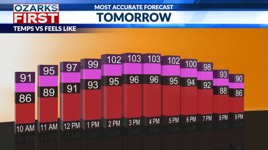
Temperatures on Saturday will be just as intense as what we experienced on Friday. Highs will climb into the upper 90s, with the heat index ranging between 100 and 107 degrees.


If you're planning to be outdoors, don’t forget to apply sunscreen and stay hydrated. While it will be hot, a few occasional breezes from the south may offer some brief relief.

Hot and dry conditions will continue into Sunday, although increasing afternoon cloud cover could help keep temperatures slightly cooler. A potential shift in the weather pattern arrives late Sunday.


A strong low-pressure system is expected to bring rain chances overnight Sunday through Tuesday. It has officially been 21 days since Springfield last saw measurable rainfall, so this will be a welcome opportunity to end that streak.
Scattered showers will be possible as we start the workweek. While no day looks like a complete washout, periods of scattered showers and isolated thunderstorms are expected. The heaviest rainfall totals will likely occur north of I-44.

Do your best to stay cool this week. Temperatures are expected to remain in the 90s through at least mid-August.
What's Your Reaction?