Heatwave to bring near triple-digit temps
A heatwave has arrived, with temperatures expected to reach the upper-90s and potentially the triple digits, prompting a heat advisory for all counties along and west of Highway 65, and a cold front is expected to bring temperatures back to normal by Wednesday.
Well, I'm sure you've already noticed, but the heatwave has officially arrived. Temperatures climbed into the mid-90s today under mostly sunny skies, and unfortunately, it’s only going to get hotter from here.


Highs are expected to flirt with the triple digits each day through the end of the week, with this heatwave potentially delivering the hottest temperatures we've seen in 2025 so far.

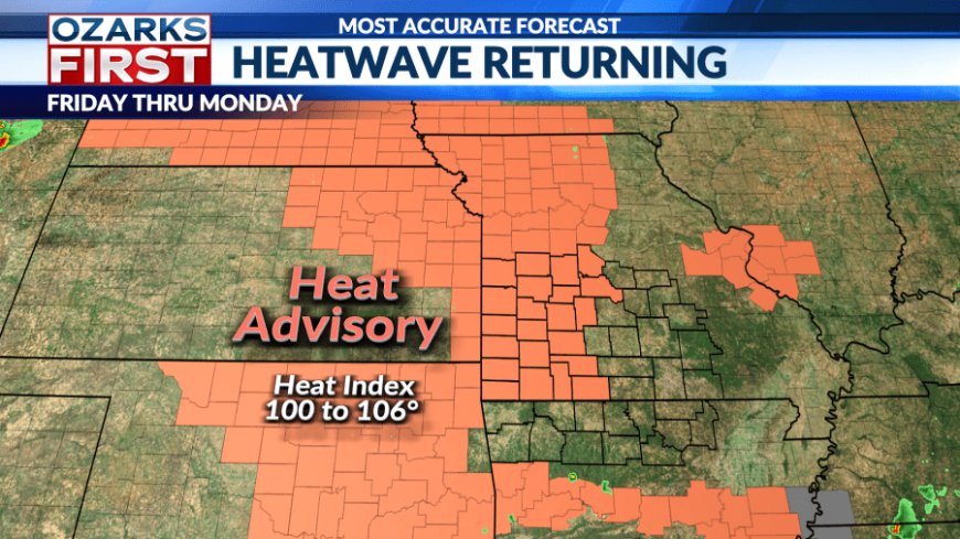
The National Weather Service has issued a heat advisory for all counties along and west of Highway 65. The advisory goes into effect at noon tomorrow and is set to remain in place through at least Monday evening, though it will likely be extended into Tuesday.

Afternoon heat index values will range from 100 to 106 degrees, making outdoor activity especially dangerous during peak hours.
Some relief is on the horizon, but it’s coming slowly. A cold front is expected to move through the Ozarks on Wednesday, bringing temperatures back down to more seasonal levels.

As for rain chances, don’t expect much. An isolated shower might pop up over the weekend, but it’s unlikely. More widespread scattered showers are possible Wednesday and Thursday, though early estimates suggest rainfall will be light, just enough to leave you wanting more.
What's Your Reaction?