


Hopes of some rain with temperatures getting back to normal
The September sizzle will continue for a few more days before temperatures can return to normal. This is compliments of a September heat dome. The dome of hot, late summer air will gradually get squeezed out over the next couple of days. In the meantime, we'll also have a chance for some pop-up showers and [...]
The September sizzle will continue for a few more days before temperatures can return to normal. This is compliments of a September heat dome.

The dome of hot, late summer air will gradually get squeezed out over the next couple of days. In the meantime, we'll also have a chance for some pop-up showers and thunderstorms thanks to the squeeze play that's going on.

For tonight, clouds will linger overnight along with a slight chance for a stray shower here and there.
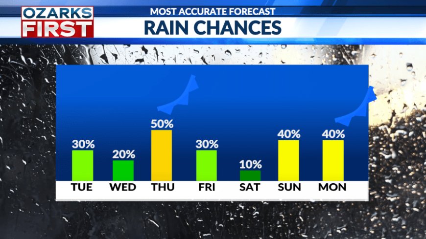
The squeeze play that's thinning the heat dome will also continue to generate a risk of scattered showers and thunderstorms on Tuesday afternoon. Drier air working in from the east will keep most of the showers near and west of Hwy. 65, with the risk of rain edging a little further west on Wednesday.


Temperatures will continue to have more of a summer feel, at night and during the day. Highs will likely make it to or a little over the 90° mark Tuesday and Wednesday, making for an unusually long streak of 90° days in September.
The heat dome will fully break down by Thursday with a weak front moving across the area. Scattered showers and thunderstorms are expected, with most areas keeping highs below 90°.
There will still be a chance for rain on Friday, but drier air will be working in from the west, keeping the focus for rain to the east.

Saturday looks dry for most areas with scattered showers and thunderstorms possible Sunday into Monday as the next cool front approaches.

Temperatures Friday into early next week will run pretty close to normal, with lows in the low to mid 60s and highs in the low to mid 80s.
What's Your Reaction?


