Next heatwave getting underway
A heatwave is underway with temperatures expected to rise throughout the week, with little to no rain expected until a cool front approaches the area late in the weekend.
Our run of cooler weather is over, and a new heatwave is underway. Tuesday was the transition day after a cool morning gave way to our first 90° highs since July 30th.

Summer heat will continue to surge throughout the rest of the week with daily jumps in high temperatures. The overnights will be getting warmer as well. The good news is that this won't be an overly humid pattern. That should keep "feels like" temperatures manageable.


Little to no rain is expected in the region into this upcoming weekend. We will be in a pattern where storm complexes could fire up across Nebraska and Iowa, but the expectation is for them to quickly fall apart as they spill toward the area. The result, maybe some leftover clouds and a very slight chance for rain toward Central Missouri.

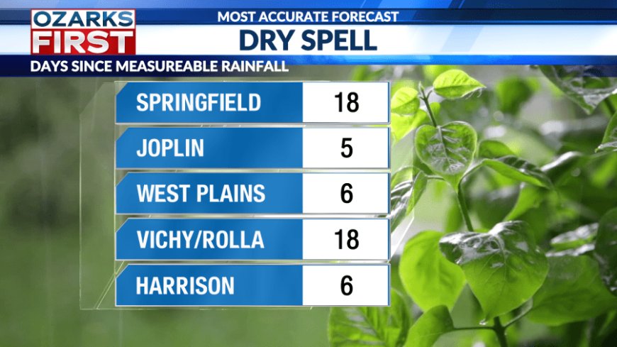
The lack of rain is becoming a problem with much of the area now entering week three of no rain. Much of Springfield has gone 18 days without measurable rain, and it has really dried out.

There will be a bit of a pattern shift late in the weekend into early next week that will allow a cool front to approach the area. This should help focus moisture and rain chances, giving us a better shot at some much-needed rainfall.

What's Your Reaction?