So long summer heat as we fast-forward to September
A cool front has brought an early fall feel to the region, with mild temperatures, low humidity, and a mix of sun and clouds expected through the weekend, before a hotter air mass moves back in next week.
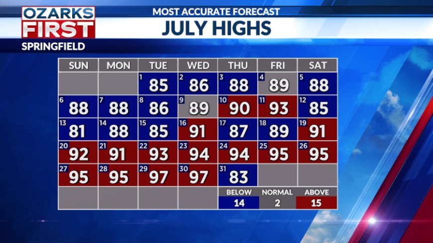
The longest heatwave in two years is over. In its place more of an early fall feel that you would expect in September.

The cool front that's delivering the breath of fresh air is also producing quite a bit of cloudiness and some spotty showers.


As we slip through tonight and then Friday, we'll find the focus for clouds shifting to Northern Arkansas. Showers will also remain possible south of a Neosho to Gainesville line. By Friday afternoon, we'll all be enjoying low humidity, mild temperatures, and a mix of sun and clouds.


The early taste of fall will make for ideal outdoor weather through the weekend. This is a rare opportunity to do some summer camping and hiking where you don't have to contend with high humidity and hot temperatures. You won't have to deal with summer thunderstorms either, with dry weather expected.


Looking ahead, cooler temperatures are expected to stick around into early next week.

A surface high positioned near the Great Lakes will keep a steady flow of milder, low-humidity air blowing into the Ozarks on easterly winds. It will almost be like air conditioning, but it will gradually get shut off as winds become more southerly later next week.

This will allow a hotter air mass to shift back into the Ozarks, and the result will be highs back in the 90s.

As for rain chances, don't look for much. There will be some rain triggers moving through at times next week, but the lack of moisture will make it tough for them to produce. Opportunities look better the following weekend as another cool front approaches the region.
What's Your Reaction?